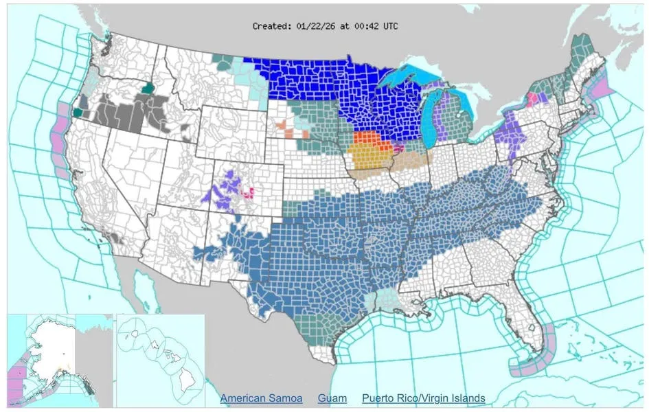
At the time of writing Thursday, the number of counties and states under Winter Storm Watches was stunning. I do not recall seeing a winter storm footprint this massive since the "Storm of the Century" in 1993, and candidly, many of the counties in the Mid-Atlantic region have not been included yet. They will be, however, in the coming hours. Here are three surprising facts about this massive weekend winter storm.
Possible Historic Extent
Weather expert Jason Furtado is a meteorology professor at the University of Oklahoma. He told NPR that it is one of the most widespread and significant winter storms he has seen in some time. At Weather.com, Rob Shackelford and Jonathan Erdman noted that the storm could impact 33 states and 180 million people. That's roughly half the entire U.S. population y'all. By comparison the 1993 "Storm of the Century" caused $2 billion in property damage and affected 22 eastern U.S. states, according to the National Weather Service. The storm also resulted in over 200 direct or indirect fatalities.
A Long-Duration, High-Impact Event
The storm will start to get its act together. It is expected to be a sprawling, long-duration event. Heavy snow is expected from the Southern Rockies to the Mid-Atlantic region. Washington D.C. could see one of its largest snowfall totals in recent years. It would not surprise me to see over a foot of snow in some areas across the massive swath with this storm.
For those of us in the Deep South, widespread freezing rain and sleet is the concern. That's never a good forecast because ice can be so crippling to the transportation network, power grid, and trees. The Lower Mississippi Value, Tennessee Valley, Southeast, and parts of southern Virginia are most likely to deal with tree damage, power outages, and treacherous travel conditions. Something that I am also paying attention to is the wind. Here in North Georgia, we could see wind gusts up to 30 miles per hour. That's never a good mix with rain or icy conditions.
Hurricane Hunters Are Flying Aspects Of The Storm
Because the storm has such high-impact potential Hurricane Hunters flew into the emerging storm off the coast of California yesterday. Data collected will help improve analyses and forecasts of the storm at locations far away from California. Though not perfect, here is an analogy for context. Like water, the atmosphere is a fluid. Weather models predict how this fluid changes so getting more data days in advance can be helpful for 1-to-5 day forecasts.
Let's consider a rock thrown into a pond. I can determine some things about the waves rippling away if I know how hard the rock was thrown into the pond, at what angle, the depth of the water, and pond width. This mission was a part of an ongoing effort to understand the role of atmospheric rivers in our weather processes.
Richard Henning is a retired air force officer and former NOAA Hurricane Hunter. He noted that the higher-altitude NOAA G-IV planes were also flying missions to collect information in the Gulf. He told me, "All the global models now assimilate these high altitude dropsondes. The USAF WC-130s provide data from around 300 millibars down to the surface and the NOAA G-IV from 150 millibars to splash." Dropsondes from the airplanes essentially provide similar information as weather balloons but in the opposite direction. That information can improve accuracy of initial conditions and downstream forecasts in the model.