Cutter joined the WJZ First Alert Weather Team in March of 2025. Born and raised in the Gulf Coast, Cutter developed his love for weather while tracking hurricanes and watching pop-up summer thunderstorms in Houston. His first on-air role was in Lubbock, Texas, while attending Texas Tech University.
A storm system is bringing a steady, chilly rain to much of the Mid-Atlantic this morning. Farther north, snow is accumulating across portions of Pennsylvania and the tri-state area. Cool and gloomy weather continues ahead of the next chance of rain later this week.
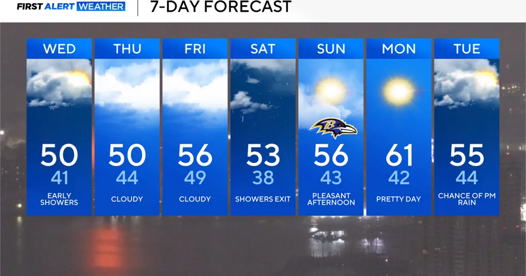
More than half an inch of rain has falling across the I-70 corridor and much of the Baltimore metro since Tuesday evening.
Steady light, to moderate, rain continues to fall early this morning. Wet weather comes to an end across Frederick and Carroll Counties first. It'll be noticeable drier after 5 a.m. In Baltimore, rain tapers off after 5:30 or 6 a.m. Scattered light rain may linger north of Route 50 on the eastern shore until 8 a.m.
Temperatures are in the low to mid-40s this morning. With a cloudy sky in the afternoon forecast, temperatures will only manage to peak in the upper 40s and lower 50s by 3 p.m. with dry conditions.
We'll see far more clouds than sun over the next 72-hours. Temperatures peak in the upper 40s and lower 50s each afternoon, with morning temperatures bottoming out in the upper 30s and 40s.
The next chance of rain arrives later on Friday. Scattered showers are possible during the afternoon and evening hours on Friday. Rain becomes more widespread Friday night, into Saturday. Rain may be heavy at times, especially south of Baltimore. The First Alert Forecast dries out Saturday afternoon.
The rest of the weekend features pleasant weather, including for the Ravens home game on Sunday. Temperatures peak in the mid-50s, with quite a bit of sunshine during the game.
The next big change in our weather is set to arrive right around the big holiday. Temperatures trend much warmer leading up to Thanksgiving as the next strong front approaches Maryland.
Showers and a few storms will accompany the front through the state. The chance of rain starts to increase on Tuesday. Right now, it looks like the greatest chance of rain will occur on Wednesday. Much colder weather blows into Maryland behind the front. Its arrival time will determine how it feels outside on Thanksgiving.
It's possible that Thanksgiving could become chilly through the day. Cold weather is even more likely Black Friday on into the holiday weekend. This will probably end up being the coldest stretch of weather so far this season. Multiple hard freezes are possible. Afternoons may remain in the 30s.
There is still uncertainty with this developing weather pattern. The WJZ First Alert Weather Team will let you know if weather will impact your holiday travel or celebration plans.