An expected rain deluge and a possible tropical cyclone are posing fresh threats to already hard-hit communities in Queensland's far north.
Tropical Low 12U, stationed east of Cooktown, is preparing to make a sharp southwest detour towards the state's north coast.
There was 'a high chance of a tropical cyclone development now in play', with the weather system's impact expected to be felt within 24 hours, the Bureau of Meteorology's Angus Hines said on Friday.
The bureau had taken the unusual step of issuing a flash tropical cyclone warning - an official term used when it issues an warning without an official 'watch' period beforehand.
But Mr Hines said that whether 12U developed into a cyclone or not, the impacts were likely to be the same.
He said widespread flooding was expected after the system crossed the coast, which was projected for early Sunday morning.
Mr Hines said heavy falls were likely to begin from Friday evening, with six-hour rainfall totals of between 90 and 170mm from Cooktown to Mackay, and 24-hour rainfall totals up to 350mm.
'That is a whole lot of wet weather,' he said.
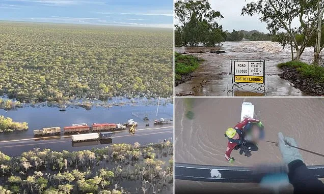
An expected rain deluge and a possible tropical cyclone are posing fresh threats to already hard-hit communities in Queensland's far north (pictured, flooding in Cloncurry)
Flooding is seen at Peets Bridge earlier this week
Trucks are seen stranded near Normanton after severe flooding
Flooding in Cloncurry is seen after severe flooding
A man was winched to safety after his campervan was caught in floodwaters
From Sunday, he said the focus would shift southwards, with the tropical low gradually moving inland from central Queensland.
'We're actually going to see a bit of a departure from this tropical low being the key area of focus,' he said.
'Most of the rain is going to separate from the low and start to affect areas through the central coast, the Capricornia, the central highlands and potentially all the way down to southeast Queensland over Sunday and Monday.'
Mr Hines predicted that multi-day totals up to 500mm from Cairns to Mackay were possible, with between 150 and 300mm forecast from Mackay south to Gladstone.
The picture was less clear in the densely populated southeast of the state, but falls up to 100mm were possible, with most of the rain expected on Monday and Tuesday.
In the northwest, major flooding that has already heavily affected Gulf Country communities - where livestock losses are projected to be significant - continues on the Flinders River.
Major flood warnings have also been issued for the Herbert, Haughton and Tully rivers.
But Mr Hines warned that a far greater area could be affected.
'Given how much rain is still to come, we absolutely could see other rivers anywhere along this northern coastline between Cairns and Rockhampton will see some flooding in the coming few days,' he said.