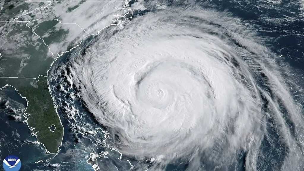
Huge waves created by the remnants of Hurricane Erin risk putting holidaymakers in peril as they flock to beaches in Cornwall today to enjoy record heat.
Thousands of sun-seeking Brits are set to flock to beaches and beauty spots across the country today in what is set to be the hottest August Bank Holiday in 60 years.
However Hurricane Erin could see huge waves crashing into Britain in the coming days as the huge US storm barrels across the Atlantic.
It has sparked warnings from Coastguards in the south west that children could be 'swept out' to sea in the harsh conditions.
James Instance, HM Coastguard Divisional Commander, said: 'Conditions in the Atlantic are predicted to mix with high tides to raise the risk in areas which are expected to be busy with visitors during the holidays.
'There is the likelihood of strong waves and currents which could lead to people being swept out, particularly children or vulnerable people.'
The RNLI has also urged people to stick to lifeguarded beaches and stay cautious of rough seas.
Despite the danger, thousands of holidaymakers are still likely to head to the county and other beaches across the UK to enjoy the heat.
The sunshine has come from a 400-mile wide 'Spanish sizzle' as heat from 44C Spain arrives in the UK.
Even northern areas of the country could see highs of 26C later today, one degree higher than the Moroccan capital Rabat.
Temperatures over 28.2C would make today the second hottest late August Bank Holiday since it began 60 years ago in 1965, and the hottest for six years, since 2019's record 33.2C, Met Office records showed.
The highest number of cars of the weekend is due on the roads today as the best weather of the weekend triggers up to 10 million more Brits taking last-minute day trips, VisitEngland data showed.
Trippers will clash with millions of staycationers heading home this afternoon (Mon) at the end of the long weekend.
A coastguard team in Boscastle, Cornwall has also issued a warning to visitors about the potential of large waves and high water levels.
A spokesperson said: 'Visitors to the south-west coast are being advised to take extra care next week as strong swells are forecast to affect parts of the coast of Cornwall, Devon and south Wales.
'Storms in the Atlantic and spring tides are likely to combine to generate large waves as well as higher than usual water levels from late Monday afternoon (25 August) into Wednesday (27 August).
'Follow our simple guidance to ensure you have a fun day and come home safe: Swim at a lifeguarded beach if you can, and pay attention to the flags, check the tide times and keep an eye on the sea state, if the sea is rough.
'Consider taking a dip on a calmer day, carry a charged-up mobile phone in case you need to call for help and if you see an emergency by the coast, call 999 and ask for the Coastguard.'
The risky conditions are set to continue into Tuesday, where waves of up to five metres could hit the Cornish coast.
A forecast on surf-forecast.com said the swell could be so powerful in St Ives it won't be possible to surf as the 'break may be maxing out'.
A Met Office forecaster said: 'The remnants of ex-Hurricane Erin will see a band of rain, which could be heavy, pushing over the UK, displacing our settled weather and bringing more spells of rain and perhaps strong winds in places by midweek.'
The RNLI has warned that the conditions could become dangerous for anyone entering the water later this week.
Chris Cousens, RNLI water safety lead, said: 'We want people to enjoy the bank holiday and stay safe, and with this unusually big surf forecast for this time of year likely to peak later in the bank holiday weekend and early next week, it's important for people to be aware so they can keep themselves and their families safe.
'Big surf means greater risk from rip currents, and the swell also coincides with spring tides, which means more powerful tidal water movement at greater speed.'
The forecast is changeable, so things might look different over the next couple of days.
Now, the Met Office has warned that remnants of Hurricane Erin are set to bring 'very large waves' to the UK, with those visiting the coast warned of an increased danger.
'But we do know that with the current forecast for bigger waves building and arriving towards the end and the day after the August bank holiday weekend, beaches are likely to be busy with holidaymakers and locals.
'Some places could see bigger waves building through the weekend too.
'We always advise people to visit a lifeguarded beach where possible - but we also appreciate people will be out on the coast where lifeguards are not present.
'Rip currents are powerful channels of water that become more powerful in larger surf.
'They are also found around river mouths, estuaries and man-made structures like piers and groynes.
'Our rip current advice is the same whether you are at a lifeguarded beach or not. If you find yourself caught in a rip current don't fight against it or you'll get exhausted.
'If you can stand, wade back to shore, or swim parallel to the beach until you're free of the current, then return to the beach. Alternatively, if you can't do either of those or are becoming exhausted, Float to Live to preserve your energy and then wave and shout for help.'