This story is from Floodlight, a nonprofit newsroom that investigates the powers stalling climate action.
On a quiet street near the marsh in Charleston, South Carolina's Rosemont neighborhood, Luvenia Brown watches the weather reports more than she used to. She's lost lawn mowers, bikes and outdoor furniture to the rising waters that have repeatedly crept into her yard.
Brown's home is elevated, so the water hasn't reached the interior. Not yet. But she's deeply worried about what the future will bring.
"If the water continues rising the way it is, I don't want to be here," said Brown, 58, who works as a medical driver. "I love my area. But I think my life is more important."
Just a half mile to the south, a massive new development - expected to bring stores, offices and 4,000 homes - is springing up. Brown worries that all the new concrete and pavement will only make flooding where she lives worse.
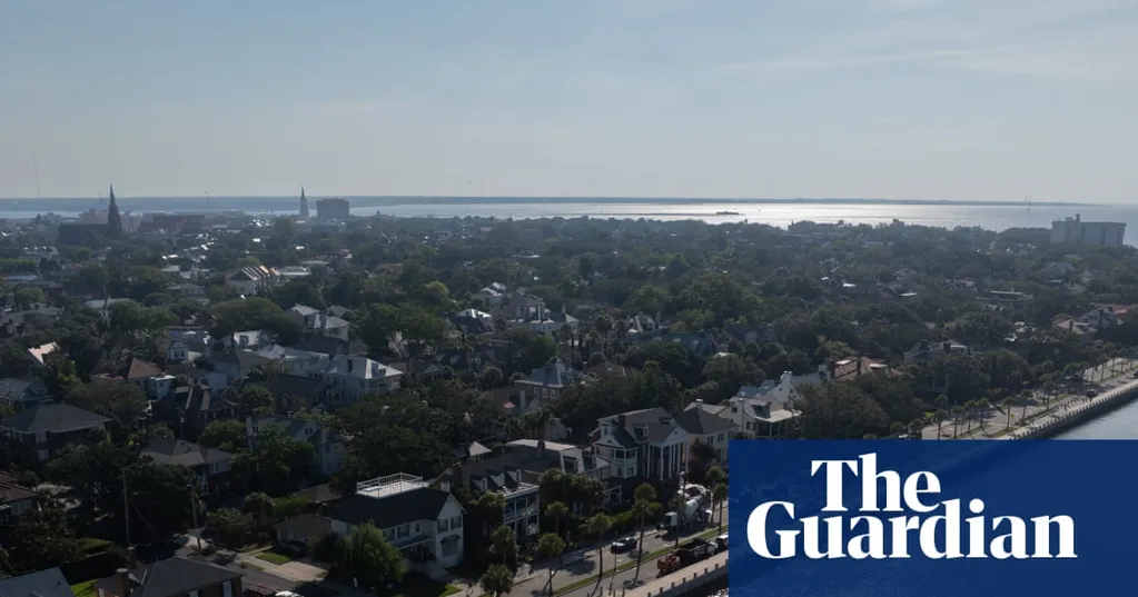
Charleston is one of the nation's fastest-growing cities - and one of the most flood-prone. As climate change prompts sea levels to rise and storms to grow more intense, this historic city has become a warning bell for what's to come along America's coasts: Some neighborhoods will retreat and others will be protected, and still others - often lower-income communities - may be left behind.
In Charleston, those futures are colliding. The city and the federal government are planning a $1.3bn sea wall to defend the iconic downtown peninsula with its regal, pre-civil-war mansions and majestic moss-covered live oak trees.
But under the current plans, the wall would not extend to lower-income neighborhoods like Rosemont, a historically Black community bordered by a freeway and hemmed in by industrial sites. That could leave those families more exposed to rising waters than ever.
"I've seen how all those floodwaters demolish people's houses," Brown said. "I don't think I want to be part of that."
Dozens of coastal cities from New York to California face similar threats. Driven largely by sea level rise, flooding in the coastal United States is projected to occur 10 times more often over the next 25 years, according to a recent analysis by the non-profit Climate Central. An estimated 2.5 million Americans could be forced to relocate over the next 25 years, the group found.
Nationally, poor communities are disproportionately affected by hurricanes and flooding, research shows.
The increasing floods are prompting insurance companies to raise premiums and decline policy renewals, creating incentives for residents to leave their homes. In fact, zip codes in coastal South Carolina are among those with the highest insurance non-renewal rates, according to a Brookings Institution analysis.
Charleston was built along the confluence of three rivers and the Atlantic Ocean, on marshland and mud flats. Flooding there was once far less frequent.
But now, even an afternoon thunderstorm or an unusually high tide can overwhelm drainage systems and submerge streets. The sea level in Charleston rose about 13in over the past century, according to the National Oceanic and Atmospheric Administration, and by 2100 it's expected to rise about 4ft more.
Charleston is also one of the most rapidly sinking cities in the United States, mainly because of groundwater pumping and the settling of natural sediments and filled marsh areas. That double threat - rising seas and sinking land - leaves the city increasingly exposed to flooding.
According to Climate Central's Coastal Risk Finder, more than 8,000 people and 4,700 homes in Charleston county will be at risk of annual flooding by 2050, even under moderate climate action scenarios. By 2100, more than 60,000 people could be affected.
Rapid development, meanwhile, is paving over forests and wetlands that once soaked up stormwater. Every new subdivision and strip mall replaces absorbent ground with impervious surfaces - asphalt, rooftops, parking lots - that send rainwater rushing into neighborhoods such as Rosemont.
After Hurricane Matthew sent water surging over Charleston's Battery wall in 2016, city officials consulted with Dutch flood experts and developed a comprehensive plan to protect the city against flooding. Federal officials proposed an eight-mile-long, $1.3bn sea wall to shield the city's historic peninsula from future storm surges and sea level rise.
The city's share will probably be $455m, Charleston's mayor, William Cogswell, recently told a city committee.
But neighborhoods like Rosemont - just beyond the wall's reach - would remain exposed. Parts of the neighborhood are projected to be underwater by the end of the century. And some have voiced concerns that the wall could actually make flooding worse in unprotected areas.
Skip Mikell, a longtime community leader in Union Heights, a historically Black neighborhood near Rosemont, stood at the end of Peace Street in Rosemont, looking out over the marsh.
"In 70 years, where we're standing, if nothing's done, it's going to be water," Mikell said, adding: "The gentry of Charleston have connections, they have money, they have a voice. These communities are voiceless."
Retreat has already started to happen in Charleston. About 11 miles west of Rosemont, a tranquil expanse of weeds, marsh grasses and black-eyed Susans is all that's left of Bridge Pointe, once a compact community of 32 townhomes. Beginning in 2015, the neighborhood experienced a succession of floods, and in 2017, Fema authorized $10m to buy out Bridge Pointe’s residents and some of their neighbors.
The neighborhood had experienced four major floods by then, making homes "really unsellable", said John Knipper, one of the displaced residents.
It took nearly four years after buyout discussions began for residents to get money for relocation. A typical buyout can take more than five years, according to the Natural Resources Defense Council. The US Government Accountability Office, meanwhile, found that there's no national strategy for relocating people from flood-prone areas.
As former Bridge Pointe residents piece their lives back together, new homes will soon go up in another flood-prone area just a mile away.
Long Savannah is expected to bring up to 4,500 homes. It’s one of several massive projects rising across Charleston county, including Magnolia Landing and Cainhoy, 4,000- and 9,000-home developments. The developers of Long Savannah have received approval to fill and excavate wetlands, which environmentalists say are crucial to soaking up rain and keeping flooding in check.
The developers of Long Savannah and Magnolia Landing did not respond to requests for comment. A spokesperson for Cainhoy noted that the project was on higher ground than other flood-prone areas and that 3,500 acres of wetlands will be preserved.
In the Cainhoy case, a federal judge in 2022 dismissed flooding concerns, citing a US army corps of engineers report which concluded the development has a "high percentage of wetlands and ... numerous direct outfalls to tidal waters that will minimize the potential for heavy rains to overwhelm its infrastructure."
"Charleston has a history of building in repetitively flooded areas," said Robby Maynor, a climate campaign associate with the Southern Environmental Law Center which along with other environmental groups contested a decision by state environmental officials to allow new development on wetlands in the Long Savannah project. "We absolutely must stop building in low-lying and flood-prone areas to avoid making an already difficult situation even worse."
City floodplain officials didn't respond to requests for an interview. But in a brief email to Floodlight, the city floodplain manager Caroline Schnell pointed to flood protections - such as higher elevation standards and better stormwater systems - for new buildings in flood-prone areas.
Ana Zimmerman has also been vocal about the dangers of letting developers fill creek-beds and build on low-lying areas.
In 2005, she and her husband bought their modest one-story home in a close-knit James Island neighborhood just south of downtown. Like much of the area outside the city's historic core it falls beyond the protection of Charleston's planned sea wall.
The first sign of trouble came early one morning in October 2015. It was still dark when she put her feet to the bedroom floor; water lapping at her ankles. A powerful storm had overwhelmed the street. Zimmerman rushed to save photo albums and the family cats but the house suffered more than $80,000 in damages.
With the insurance payout and their own labor, the Zimmermans repaired the home.
But when Tropical Storm Irma hit two years later, Zimmerman remembers hearing neighbors screaming as 7in of floodwaters poured into her home—causing it to be declared a total loss.
Ultimately the couple abandoned the flood-damaged home and let it go into foreclosure, walking away from 12 years of equity. They now live nearby in a house on an elevated foundation. Zimmerman—who calls herself an “unintentional flood activist”—has pressed public officials for stricter building rules and clearer flood-risk disclosures.
She says her experience is a “canary in a coalmine” for other low-lying coastal communities.
"Entire neighborhoods will have to move," said Zimmerman, a college biology professor. "But the vulnerable among us there will be no one there to help them save them and they will not be able to save themselves."