Floodwaters ravaging thousands of kilometres of outback Queensland has spread into a second state as a new satellite image captures the extensive damage.
Heavy rain battered western and inland areas of the state over the last fortnight causing three rural communities to evacuate their homes with some isolated areas drenched with almost a year's worth of rain.
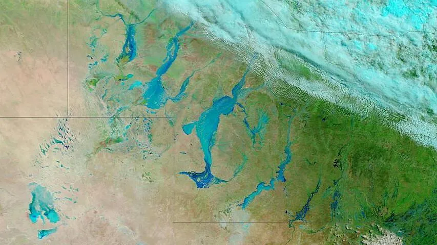
NASA's Earth Observatory captured images of the state's flooded landscape in Channel Country as the skies cleared on Thursday.
The satellite uses false colours to enhance floodwaters by making water on the ground appear blue and sediment-heavy water darker blue.
It comes as the Bureau of Meteorology revealed that widespread flooding will linger for several weeks in some areas due to water saturation.
'If the water was just going to go away, where would it go to?' the Bureau's Miriam Bradbury said.
'A portion soaks into the ground and a portion moves into our river systems.'
But Ms Bradbury told Daily Mail Australia on Friday the ground in flooded areas of southwest Queensland has become 'so saturated, it cannot absorb anymore'.
A side effect of the saturation is that floodwaters have started trickling down into New South Wales, causing flood warnings in the northern area of the state.
Rainwater flows into creeks, streams and rivers before moving to northern NSW where communities are still being drenched by more rain.
The state is 'getting it from all angles', Ms Bradbury said.
'Some of the flooding is driven by rain in some of those areas, but some at Warrego River has flowed down from Queensland areas,' she said.
She said the extent of the flooding 'remains to be seen' over the next few weeks.
The Bureau said heavy rainfall has eased across southern Queensland with a weak trough to linger in central and northern areas on Friday before moving north.
But with flooding set to last for weeks and rivers expected to remain high, locals have been heavily impacted by the ongoing deluge.
It comes after a man and his horse were rescued by police and emergency services from floodwaters at the rural town of Tambo on Wednesday.
Shortly before 5.30am, the 31-year-old was travelling from his home in Blackall to Toowoomba to get surgery for his wounded horse.
Queensland Police said the man was unable to see the flooded creek and was immediately swept off the roadway along with his horse.
The driver climbed on top of the roof of his 4WD until emergency services arrived a short time later.
Longreach Disaster Coordinator Inspector Chris Smith said the incident is another reminder to be vigilant during severe weather.
'When it is dark, it is often difficult to see that a road could potentially be hazardous. No matter how shallow it may look, it's not worth risking your life or the lives of emergency services who rescue you,' he said.
'It may seem like an inconvenience, but by taking the time you need to seek alternate routes, it may just save your life.'
Police said 27 residents were evacuated from Adavale and a number of people were relocated from Jundah and Thargomindah.
A home is surrounded by floodwaters near the town of Jundah in Queensland's southwest
The extent of the flooding 'remains to be seen' over the next few weeks
Queensland Police said about 27 people were evacuated from Adavale, and a number of people were relocated from Jundah and Thargomindah
Flooded roads and homes are seen in Thargomindah in Queensland's southwest
Heavy rainfall has eased across southern Queensland but flooding is expected to linger for weeks, according to the Bureau of Meteorology
Flooded homes are seen in Thargomindah in Queensland's southwest on Thursday
Heavy rain battered western and inland Queensland in the last fortnight causing some communities to evacuate (SES crews are seen on floodwaters)
A side effect of the saturation is that floodwaters have started trickling down into New South Wales, causing flood warnings in the northern area of the state.
Rainwater flows into creeks, streams and rivers before moving to northern NSW where communities are still being drenched by more rain.
The state is 'getting it from all angles', Ms Bradbury said.
'Some of the flooding is driven by rain in some of those areas, but some at Warrego River has flowed down from Queensland areas,' she said.
She said the extent of the flooding 'remains to be seen' over the next few weeks.
The Bureau said heavy rainfall has eased across southern Queensland with a weak trough to linger in central and northern areas on Friday before moving north.
But with flooding set to last for weeks and rivers expected to remain high, locals have been heavily impacted by the ongoing deluge.
It comes after a man and his horse were rescued by police and emergency services from floodwaters at the rural town of Tambo on Wednesday.
Shortly before 5.30am, the 31-year-old was travelling from his home in Blackall to Toowoomba to get surgery for his wounded horse.
Queensland Police said the man was unable to see the flooded creek and was immediately swept off the roadway along with his horse.
The driver climbed on top of the roof of his 4WD until emergency services arrived a short time later.
Longreach Disaster Coordinator Inspector Chris Smith said the incident is another reminder to be vigilant during severe weather.
'When it is dark, it is often difficult to see that a road could potentially be hazardous. No matter how shallow it may look, it's not worth risking your life or the lives of emergency services who rescue you,' he said.
'It may seem like an inconvenience, but by taking the time you need to seek alternate routes, it may just save your life.'
Police said 27 residents were evacuated from Adavale and a number of people were relocated from Jundah and Thargomindah.
Weather Forecasts
Sydney
- Friday. Max 26. Partly cloudy. Slight chance of an afternoon shower, most likely near the coast. Light winds.
- Saturday. Min 16 Max 25. The chance of fog in the early morning. Sunny day. Winds west to southwesterly 15 to 20 km/h turning south to southeasterly in the late morning then becoming light in the evening.
- Sunday. Min 15 Max 27. Sunny. The chance of morning fog in the west. Light winds.
Melbourne:
- Friday. Max 19. Partly cloudy. Light winds becoming southwesterly 15 to 20 km/h in the morning then tending westerly in late evening.
- Saturday. Min 12 Max 18. Partly cloudy. High chance of showers about Dandenongs; medium chance elsewhere. Winds westerly 15-25 km/h tending southwesterly early morning then becoming light evening.
- Sunday. Min 9 Max 21. Becoming cloudy. High chance of showers southeast suburbs; medium chance elsewhere. Winds north-northwesterly 15-25 km/h turning westerly 25-40 km/h during morning then decreasing 20-30 km/h during evening.
Brisbane
- Friday. Max 28. Partly cloudy. High chance of showers, most likely in morning and afternoon. Light winds becoming east-southeasterly 15-20 km/h early afternoon then becoming light evening.
- Saturday. Min 19 Max 29. Partly cloudy. Medium chance of showers. Light winds.
- Sunday. Min 19 Max 28. Partly cloudy. Medium chance of showers, most likely in morning and afternoon. Light winds.
Canberra
- Friday.Max 23.Partly cloudy.Light winds becoming northwesterly 15 to 20 km/h in late afternoon then becoming light in evening.
- Saturday.Min 6 Max 23.Sunny.Light winds becoming northwesterly 15 to 20 km/h in early afternoon then becoming light in evening.
- Sunday.Min 3 Max 21.Sunny.Light winds becoming west to northwesterly 15 to 25 km/h during morning then becoming light during evening.
Adelaide
- Friday.Max 21.Partly cloudy.Slight chance of a shower about southern suburbs in afternoon, near zero chance elsewhere.Light winds becoming southwesterly 15 to 25 km/h in middle of day then tending southerly 15 to 20 km/h in evening.
- Saturday.Min 12 Max 22.Partly cloudy.Slight chance of a shower about southern suburbs, near zero chance elsewhere.Light winds becoming southwesterly 15 to 20 km/h in early afternoon then becoming light in evening.
- Sunday.Min 10 Max 23.Partly cloudy.Medium chance of showers in afternoon and evening.Light winds becoming westerly 20 to 30 km/h during morning then tending southwesterly 15 to 25 km/h during afternoon.
Perth
- Friday.Max 25.Partly cloudy.Very high chance of showers.The chance of a thunderstorm.Winds easterly 30 to 50 km/h.Gusts to 85 km/h are possible about hills and foothills, with damaging winds possible in evening.
- Saturday.Min 15 Max 27.Partly cloudy.Medium chance of showers, most likely in morning.The chance of a thunderstorm about northern suburbs.Damaging winds possible in east in morning.Winds easterly 35 to 50 km/h decreasing to 15 to 20 km/h in evening.Gusts to 85 km/h are possible about hills and foothills in morning.
- Sunday.Min 17 Max 30.Partly cloudy.Medium chance of showers.The chance of a thunderstorm.Winds easterly 15 to 25 km/h tending northwest to southwesterly 15 to 20 km/h during afternoon then becoming light during evening.