After a week of extreme heat, cities across Australia are now bracing for wet, stormy days.
Despite many cities and towns recently recording temperatures upwards of 40C, new forecasts show dramatic rainfalls are on the way.
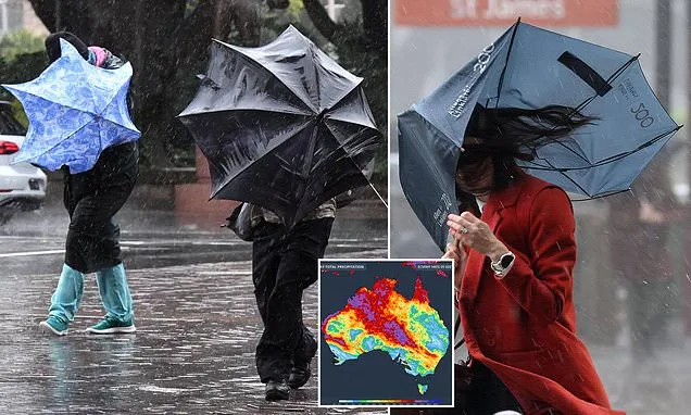
Every state and territory is expected to receive some level of rainfall in the coming days, according to Weatherzone's latest forecast map.
The Northern Territory and central Australia are expected to be hit by the worst of the oncoming fronts.
The wet and stormy cycles will hit impacted areas over the weekend and might even extend into next week.
Some areas may even experience bouts of flooding depending on how harsh the rainfall turns out to be.
Weekly rainfall totals of 100mm are expected in some areas while others could receive several hundred millimetres in the same timeframe.
Marree, in South Australia, is set to be hit by a massive rain bomb just days after the township hit temperatures of more than 40C.
Showers are expected to hit cities across Australia only one week after record hot temperatures.
While some parts of SA are still fighting lingering bushfires parts of the NT are bracing for potential floods.
Other areas of SA between Deep Creek and the Fleurieu Peninsula, south of Adelaide, are still being hit by bushfires which sprung up in recent days.
'(The) community are reminded to stay out of the current warning area where possible,' the SA Country Fire Service warned.
'Anyone within the impacted area will be allowed to leave via the closed roads but will not be able to return until they are reopened.
'Given the unpredictable nature of this fire, any road closures could change at short notice.'
In WA, severe heatwave warnings have been issued for the Gascoyne and Central West regions, including Carnarvon and Coral Bay.
Temperatures are expected to reach 42C in Newman, 39C in Karratha, and 37C between Exmouth and Geraldton across the weekend.
In central Australia however, flooding is expected to potentially cut off roads and townships as rain smashes the regions.
A tropical low travelling over WA and the Northern Territory has been upgraded to tropical cyclone level by the Bureau of Meteorology.
Rain will hit areas along the east coast as a separate low front moves westward from the Kimberley.
The low pressure system is forecast to move westwards off the Kimberley coast in northern WA and gradually build strength as it moves towards the mainland.
The BoM has also warned of winds reaching up to 120km/h in coastal areas as the low passes through on Saturday.
| Sydney | Saturday: Min 22 Max 30 |
|---|---|
| Sunday: Showers. Min 21 Max 25 | |
| Monday: Showers. Min 20 Max 24 | |
| Tuesday: Showers. Min 21 Max 26 |
| Canberra | Saturday: Possible Showers. Min 17 Max 33 |
|---|---|
| Sunday: Possible showers. Min 17 Max 24 | |
| Monday: Shower or two. Min 16 Max 25 | |
| Tuesday: Shower or two. Min 17 Max 30 |
| Melbourne | Saturday: Min 17 Max 25 |
|---|---|
| Sunday: Cloudy. Min 18 Max 25 | |
| Monday: Cloudy. Min 18 Max 25 | |
| Tuesday: Cloudy. Min 20 Max 27 |
| Hobart | Saturday: Min 15 Max 20 |
|---|---|
| Sunday: Possible showers. Min 14 Max 22 | |
| Monday: Cloudy. Min 15 Max 23 | |
| Tuesday: Cloudy. Min 16 Max 24 |
| Adelaide | Saturday: Min 21 Max 33 |
|---|---|
| Sunday: Sunny. Min 18 Max 32 | |
| Monday: Sunny. Min 17 Max 30 | |
| Tuesday: Partially Cloudy. Min 24 Max 32 |
| Perth | Saturday: Min 22 Max 23 |
|---|---|
| Sunday: Sunny. Min 23 Max 34 | |
| Monday: Cloudy. Min 20 Max 32 | |
| Tuesday: Cloudy. Min 17 Max 28 |
Adelaide and parts of WA will remain relatively hot over the next week
| Darwin | Saturday: Min 26 Max 31 |
|---|---|
| Sunday: Cloudy. Min 26 Max 31 | |
| Monday: Sunny. Min 26 Max 30 | |
| Tuesday: Cloudy. Min 26 Max 30 |
| Brisbane | Saturday: Min 22 Max 30 |
|---|---|
| Sunday: Cloudy. Min 22 Max 30 | |
| Monday: Cloudy. Min 24 Max 31 | |
| Tuesday: Cloudy. Min 24 Max 32 |