The Colorado River Basin has seen an extensive loss of groundwater loss over two decades, with more than half of the loss being in Arizona, according to a new map drawn from NASA satellite data.
Analysis by Arizona State University (ASU) researchers has revealed "rapid and accelerating" groundwater loss in the basin's underground aquifers between 2002 and 2024.
Some 40 million Americans rely on water from these aquifers, including in parts of Arizona, California, Colorado, Nevada, New Mexico, Utah and Wyoming.
The team has warned that "climate change is causing more frequent and intense droughts around the world, including in the Colorado River Basin -- which supplies water to seven U.S. states and Mexico -- and is facing severe water shortages."
The basin lost 27.8 million acre-feet of groundwater over the past two decades, which is roughly equal to the storage capacity of Lake Mead, according to paper author and ASU geoscientist Karem Abdelmohsen.
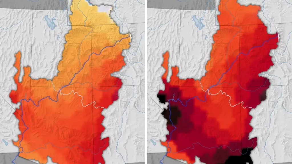
Around 68 percent of the losses occurred in the lower part of the basin, which lies mostly in Arizona.
"Lots of attention has gone to low water levels in reservoirs over the years, but the depletion of groundwater far outpaces the surface water losses. This is a big warning flag," said Abdelmohsen in a statement.
During the first decade of the study period between 2002 and 2014, parts of the basin in western Arizona (in the La Paz and Mohave counties) and in the southeast of the state (Cochise County) lost groundwater at a rate of around 0.2 inches per year. However, this rate more than doubled, to 0.5 inches per year, in the following decade.
Scientists say the acceleration of the groundwater loss is likely down to two factors, including the arrival of a "triple-dip" La Niña between 2020 and 2023.
(La Niña is an oceanic phenomenon that sees cooler than normal sea-surface temperatures in the central and eastern tropical Pacific Ocean. La Niña typically leads to reduced rainfall over the Southwest and slows the replenishment of aquifers, NASA explained. A "triple dip" is when we get three consecutive years of La Niña conditions.)
A second factor at play may be an increase in the amount of groundwater used for agriculture.
Arizona saw a rise in agricultural activity in 2014, when large alfalfa farms arrived in La Paz and other southern parts of the state. Dairies and orchards as well as other popular "thirsty" crops grown in the state, such as cotton, corn, and pecans, likely impacted groundwater supplies, Famiglietti said.
According to data from the Arizona Department of Water Resources, 72 percent of the state's available water supply is used for irrigated agriculture.
Many farms use "vast" amounts of groundwater, Famiglietti said, partly because they use flood irrigation, where water is released into trenches that run through crop fields.
The long-standing practice, commonly used for alfalfa and cotton, tends to be the cheapest option but can lead to more water loss and evaporation than other irrigation techniques, such as overhead sprinklers or dripping water from plastic tubing.
The latest study also found evidence that managing groundwater can help keep Arizona aquifers healthier. For example, the active management areas and irrigation non-expansion areas formed as part of the Arizona Groundwater Management Act of 1980 cut down water losses in some areas.
The designation of a new active management area in the Willcox Groundwater Basin is also likely to further slow groundwater losses.
"Still, the bottom line is that the losses to groundwater were huge," Abdelmohsen said.