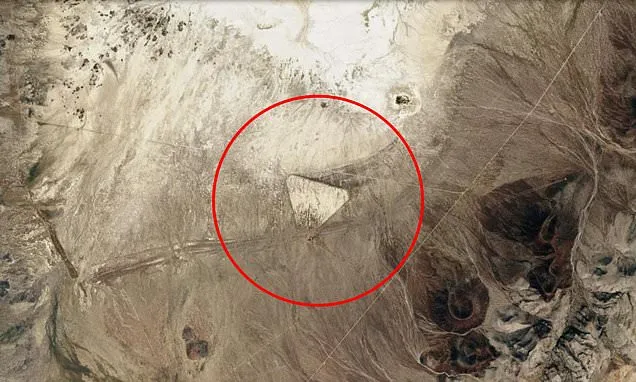
A strange triangular formation in the Nevada desert is fueling speculation that it may be the work of a long-lost ancient civilization.
Spotted on Google Earth, the structure is located in Battle Mountain, surrounded by sharp, jagged mountain ranges with deep valleys and ridges.
The structure is a large, sharply defined triangle clearly visible from above, with each side nearly straight, creating an almost perfect equilateral shape.
The center of the triangle is empty, though faint linear markings hint at past human activity.
An image of the formation and its coordinates, 40.35322, -117.34707, has flooded social media, where users suggested it could be 'a lost man-made pyramid' and are sure it is 'very ancient.'
Others have proclaimed the triangle as a 'universal Intergalactic warning sign.'
While the discovery has sparked wild theories, other social media users have shared a more realistic take, saying the structure is nothing more than remnants of an old airfield.
The formation closely matches the outline of the Buffalo Valley Intermediate Field, an emergency triangular airfield built in the 1930s to 1940s along early aviation routes.
In Nevada and other Western US deserts, triangular airfields were common in the1930s and 1940s, serving early aviation needs such as mail routes and emergency landings.
These airfields were intentionally designed in a triangular pattern so pilots could land into the wind from multiple directions.
Experts say that while such sites may look unusual from above, triangular airfields were once widespread across the American West, particularly in remote desert regions where emergency landing options were critical for early pilots.
Many were unpaved and have since been reclaimed by the desert, leaving only faint impressions visible in satellite imagery.
The unusual shapes have fueled speculation about mysterious or ancient structures. Some enthusiasts compare them to other enigmatic desert formations worldwide, sparking debates about lost civilizations, secret government projects and even extraterrestrial activity.
Last year, Google Earth users spotted another mysterious triangular structure in Nevada, this one located within the highly classified confines of Area 51.
After a shot of the tower was posted to Reddit, one user said 'it's where the aliens test their various white powders.'
Someone else posted: 'Obviously alien technology. It pops out when the Earth is done.'
On Google Maps, the unusual structure can be located using '37.24624° N, 115.82334° W' as coordinates.
It is adjacent to a vast network of buildings, cars and runways that form the highly classified region, officially called Homey Airport or Groom Lake.
The tower has what looks like a long, looping dirt pile going around it in the shape of a noose and an imposing shadow from the Nevada sunshine - leading one Facebooker to call it a 'very accurate sundial'.
Google Maps does not name the structure.
However, there appears to be a rational explanation for the tower.
The tower is used for radar cross-section (RCS) testing, where aircraft or mock-ups are mounted to measure how detectable they are to radar.
One Facebook user explained: 'Its shadow and elevated position match the known appearance of this type of pylon structure used for mounting full-scale aircraft models or prototypes.'
Variously described as 150 feet and 190 feet in height, it was reportedly constructed 20 years ago but was only acknowledged by the US government in 2013.
Largely due to the US government's secrecy surrounding its military efforts, the site will likely continue to inspire such far-fetched theories.