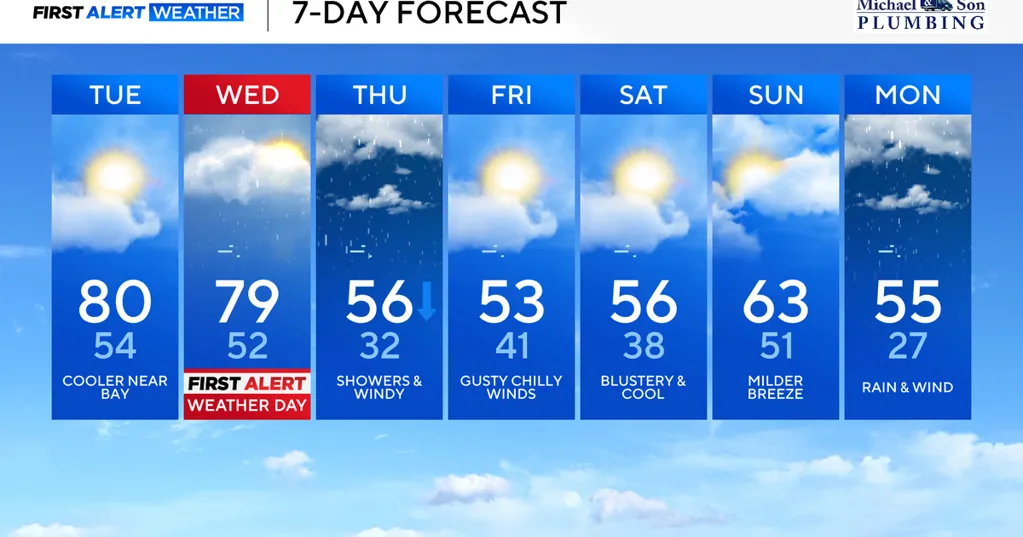
Record highs are possible Tuesday and Wednesday afternoons in Baltimore. The WJZ First Alert Weather Team has upgraded Wednesday to a First Alert Weather Day for the potential of afternoon and evening severe thunderstorms.
Early morning fog continues to dissipate across Maryland. High clouds passing through the area Tuesday morning will exit by midday. Expect plenty of sunshine Tuesday afternoon with highs approaching 80°.
The record high for BWI Marshall Tuesday is 80° set back in 2016. The record high at BWI Marshall for Wednesday is 79° set back in 2021.
We may tie the record high temperature either or both days if southerly winds don't overpower the warmth.
The exception to the unseasonably warm temperatures will be areas along and near Chesapeake Bay where high temperatures will stay in the 60s with a chilly wind off the water.
A powerful cold front will move through Maryland Wednesday. The front will be accompanied by clusters of showers and strong to severe thunderstorms.
The ingredients are there for severe thunderstorms, especially along and west of interstate of I-95 Wednesday afternoon into early Wednesday evening. Any storm has the potential to produce damaging wind gusts up to 60 mph, hail, and an isolated tornado. The greatest tornado risk looks to take place just west of the WJZ viewing area, but given trends, we'll continue to watch our area for a possible stray tornado or two.
In addition to the potential for severe weather, torrential downpours will also impact the evening commute causing travel delays in spots.
The chance of storms will increase by early afternoon and peak between 3 p.m. and 9 p.m.
Temperatures will drop 25° to 30° degrees Wednesday night as colder air arrives behind the strong cold front.
Temperatures will drop through Thursday morning from the mid-50s and settle into the middle 40s, with showers and breezy winds Thursday afternoon. A few sleet pellets or snowflakes could mix in with the light rain later in the day Thursday.
Friday will be dry, breezy and chilly. Temperatures peak in the low to mid-50s on Friday afternoon. Plan on similar weather for Saturday plans, followed by slightly warmer weather on Sunday ahead of another strong front.
After steady rain and gusty winds on Monday, expect temperatures to plummet late Monday into Monday night. Temperatures will go from the mid-50s Monday into the 20s by Monday night. Once it turns cold, it will stay cold through the middle of next week.
There are some hints in the weather pattern that could allow a storm to develop around St. Patrick's Day. While not all models agree on the track and strength of this storm, if it does materialize, some wintry weather is possible.
Stay with the First Alert Weather Team this week for updates on this weather pattern that will bring us some major temperatures swings.