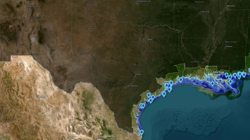
Many parts of the United States would be significantly impacted if sea levels rose 10 feet, including Texas, a projection map by the National Oceanic and Atmospheric Administration (NOAA) shows.
The map shows that a vast expanse of the state's coastal regions would be heavily flooded, or even submerged in water, if sea levels were to rise that high.
The concern around a 10 foot sea level rise is not only that it would flood major coastal cities, but also that vital service facilities like hospitals, fire stations and many others would be lost and that facilities which store, emit or handle sewage, trash and hazardous materials would also be flooded, which could have serious implications.
"Flooding can overwhelm septic systems and spread pollution, creating serious public health risks," A.R. Siders, a professor of public policy and administration and a core faculty member of the Disaster Research Center at the University of Delaware, told Newsweek.
However, it's not just a 10-foot sea level rise that is a concern.
"Even 2 to 5 feet of sea-level rise would be devastating," Siders said. "Roads, airports, homes, and businesses could be flooded not just during storms but during high tides or even permanently."
She added that saltwater intrusion can also "damage crops and contaminate drinking water sources."
Much of Texas' coastline would dramatically change if sea levels were to rise by 10 feet, according to the NOAA's map.
Starting from the northernmost point of the state's coastline, cities surrounding Galveston Bay and Trinity Bay like Texas City, Cove, Anahuac, La Porte and parts of League City would all be covered in sea water.
Hitchcock, set back from West Bay, would also be affected, as would Tiki Island, Jamaica Beach and Galveston. Wildlife areas would also be impacted, as the McFadden National Wildlife Refuge would be submerged, as well as the Jocelyn Nungaray National Wildlife Refuge.
Further down the coast, Surfside Beach, Oyster Creek and Freeport would all experience major flooding. San Bernard National Wildlife Refuge would also be submerged.
Matagorda would be partially submerged, as would a number of areas surrounding Matagorda Bay, such as Palacios. Carancahua Bay would also flood into Port Alto and Carancahua, while Keller Bay would flood Olivia, and Cox Bay would flood Point Comfort, Port Lavaca, Alamo Beach and Magnolia Beach.
Port O'Connor would be submerged in sea water, as would the Aransas National Wildlife Refuge.
San Antonio Bay would also flood into neighboring areas, and further down the coast Holiday Beach would be completely flooded with sea water as Aransas Bay would also flood. This would also affect Lamar, Rockport, Fulton, Aransas and many other areas.
Further south down Texas' coastline, Ingleside on the Bay would be flooded by Corpus Christi Bay, as would parts of Corpus Christi, Portland and other surrounding areas.
Baffin Bay would also likely flood into neighboring areas which would affect Riviera Beach, Loyola Beach and others.
The Padre Island National Seashore would also be submerged, as would the Laguna Atascosa National Wildlife Refuge, East Cameron, Port Isabel and South Padre Island.
Siders said that she thought it is "physically possible, but not on the time scales most cities plan for" and that over the course of the century the sea level rise will likely be much lower than 10 feet.
"Current science suggests most of the U.S. coast is likely to see 2 to 5 feet by 2100, with some areas higher or lower depending on local conditions like ocean currents and land subsidence," she said.
In order to avoid even higher sea level rise in the long term, Siders said it is vital that greenhouse gas emissions are significantly reduced.
"At the same time, we have to deal with the sea level rise and flood risks coastal communities are already facing," she said.
Various adaption methods cover four broad strategies, she said, which include: "resist, accommodate, avoid, and retreat."
For example, barriers like levees and seawalls would work to "resist flooding by holding back the ocean," she said, while accommodation focuses on "living with water by elevating infrastructure and using green space so flooding causes less damage."
"Communities can avoid putting new development in high-risk areas, and they can plan to withdraw from places that flood repeatedly," she added.
Although for most cities and towns it is likely that they will need a combination of all of these approaches Siders said.
"The sooner cities and states start planning the easier more affordable and less disruptive these changes will be," she added. "There is also an opportunity here: coastal communities can use this moment to think creatively about what kind of places they want to be and what kind of relationship they want to have with the sea."