Hundreds of sensors placed throughout New York City measure water as it rises, then send the data to an interactive map available to the public.
Kelly Hayes, a co-owner of Gowanus Gardens, a bar in Brooklyn, said that at least once a year, her business floods.
She has equipped herself with a metal stop to keep water from streaming in under the front door and has a sump pump in the basement. And when rainfall is heavy, Ms. Hayes keeps an eye on the data streaming online from a sensor placed a few blocks away as part of a city-backed initiative to track flooding virtually in real-time.
"We are just in the zone," Ms. Hayes said, "so if we're getting a lot of rain in a short amount of time, there is going to be flooding here."
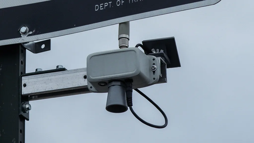
City officials brought together researchers at New York University and the City University of New York in 2020 to begin an initiative called FloodNet, which now has more than 250 flood sensors at street corners across the city, all beaming information to a data set available online at floodnet.nyc. The sensors emit ultrasonic pulses toward the ground and calculate the height of a flood by measuring the time they take to hit water. That data is delivered to an interactive map.
The project is unique among major cities because of the granular, street-level data it captures, researchers for the project said. It is funded by the New York City Department of Environmental Protection, and there are efforts underway to double the number of sensors to 500 by 2027. The city's roughly $7 million investment in the project was spurred by the flood damage after Hurricane Ida four years ago.
Elijah Hutchinson, who heads the Mayor's Office of Climate And Environmental Justice, said FloodNet is a powerful tool for identifying any safety threats. It has only grown in importance, Mr. Hutchinson added, as federal agencies have seen their budgets cut.
"The federal government is exiting the data business in a lot of ways," Mr. Hutchinson said. "And we still, at the city level, have the obligation to keep our community safe from this hazard."
Extreme weather is becoming more common because of climate change. Flash flooding caused by heavy rain is a growing problem to businesses and residents across the city, according to a 2024 report from the city comptroller.
"When Hurricane Ida hit in 2021, it was a wake-up call for just how unprepared New York City was for intense rains,"
the report concluded.
Andrea Silverman, a co-founder of FloodNet and an associate professor at the N.Y.U. Tandon School of Engineering, said the initiative shares data with city agencies including the D.E.P. and the Emergency Management Department. Environmental researchers at Brooklyn College and the Science and Resilience Institute at Jamaica Bay also contributed to the project.
The flow of information, such as the height of gathering flood water, is "essentially in real time, or with a minute or two delay," Ms. Silverman said. "So it does provide data a little bit quicker than, 'Did someone call 911?'”
Detecting tornadoes and hurricanes is commonplace. Likewise, government agencies report tsunamis, earthquakes and other natural disasters nearly as they are happening.
Yet flash flooding is uniquely hard to measure.
Until FloodNet, New York, like most other cities, tracked flash flooding by cataloging calls to emergency departments, posts to social media and reports in the news.
Satellite technology can be used to identify the presence of floodwater, but only some satellites can detect the height of the water. And in urban settings, satellites are most effective only if buildings, clouds, trees or other obstructions aren't in the way.
"Having this network of sensors that can detect what's really happening with the complexity of an urban drainage network yields really important and unique information about localized flooding in an urban environment that you really can't get any other way,"
said Beth Tellman, an assistant professor of environmental studies at the University of Wisconsin-Madison, who studies and uses satellite technology to measure flooding.
Streamgages, which monitor water levels in rivers and streams, have been used in cities with lots of car traffic and commuters for more than a decade. Charlotte, N.C., for example, reports water levels under bridges in near real time. A similar system has been created in Houston, and there are a number of state emergency departments with online dashboards of streamgage data.
In 2019, researchers at Arizona State University and other schools used traffic cameras to track flooding for a National Science Foundation-funded project called Flood Aware. They said that Arizona's flat topography made it a straightforward choice.
While these systems are useful, the relatively low cost of FloodNet coupled with its expansive reach make it the right tool for New York, city officials said. Streamgages, which can cost some $40,000 to install and thousands more for upkeep, can be extremely accurate but are considered too large and expensive for urban flood tracking. FloodNet sensors are much cheaper, at $300 a piece, and the components are easy to replace, making them more practical for long-term use in a city, researchers said.
FloodNet also combines its sensor data with other metrics available online like rainfall data from the NYC Micronet and tidal monitoring by the U.S. Geological Survey
Ms. Silverman and Charlie Mydlarz, the technical lead for FloodNet and a research associate professor at the center for urban science and progress at N.Y.U.'s Tandon, said they hope that the FloodNet network will soon be used as the basis of an alert system. They're already piloting one with email, they said. They hope to see FloodNet replicated in other cities, they said, and there are already two pilots in Puerto Rico and Brazil.
"I'd love to see a clear path to adoption for this kind of technology because ultimately it can really help,"
Mr. Mydlarz said.