MONTPELIER -- The Vermont Natural Resources Council (VNRC) has created a new online dam tracking tool in collaboration with the Dam Task Force, a group of river and fish biologists, anglers, community members, freshwater advocates, conservation organizations, and state and federal regulators who are working to restore and reconnect our rivers to support thriving fish populations, improved recreational access, and a river's natural capacity to handle flooding.
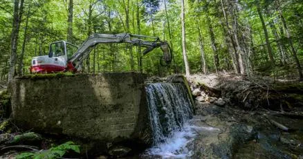
The dam tracking tool, the Vermont Dam Mapper, takes the form of an online information dashboard and associated story maps, is hosted by VNRC and the Dam Task Force's FreeVTRivers project website. The Vermont Dam Mapper shows the operational status of Vermont's more than 1,000 dams and includes narratives for 10 selected dam removal projects. Each of these projects is being mapped using drones to track pre- and post-removal conditions at each site.
Many dams in Vermont are estimated to serve no useful purpose and instead degrade water quality and aquatic habitat, restrict the movement of fish and other wildlife, increase maintenance and liability costs, and pose significant risks to public safety, according to a VNRC news release. The FreeVTRivers initiative seeks to publicize the existence of these non-functional dams and inform the public of their impacts through educational, interactive online maps, drone imagery comparisons, dam histories and removal narratives.
This information will help inform the public about how river systems change when a dam is removed, especially as the use of drone mapping imagery allows for the tracking of river restoration over time, showing habitat restoration, aquatic ecosystem recovery, and flood resilience. The Vermont Dam Mapper is designed to be used as a tool by both the public and educators to create impactful, meaningful presentations and lessons for the residents of the Lake Champlain Basin on the water quality benefits of dam removal.
The Vermont Dam Mapper was funded through VNRC as well as through grant funding from the Lake Champlain Basin Program's (LCBP) Education and Outreach Grant program. These grants support projects that address strategies and tasks outlined in the Informed and Involved Public chapter of Opportunities for Action. The Lake Champlain Basin Program coordinates and funds efforts that benefit the Lake Champlain Basin's water quality, fisheries, wetlands, wildlife, recreation, and cultural resources in partnership with government agencies from New York, Vermont, and Québec; private organizations; local communities; and individuals.
"The Vermont Dam Mapper is an excellent geographic tool that helps the user visualize the distribution of dams and dam removal projects throughout the state," Stephi Drago from VNRC said in a statement. "Over the last 26 years Vermont has successfully removed 81 dams along our rivers and streams, with more being removed every year, so this is an exciting way to share that work and show Vermont's progress with these restoration projects."
Since its founding in 1963, the Vermont Natural Resources Council (VNRC) seeks to protect and enhance Vermont's natural environments, vibrant communities, productive working landscapes, rural character, and unique sense of place while preparing the state for future challenges and opportunities by leveraging research, education, collaboration and advocacy activities.
Since 1996, the Vermont Dam Task Force has supported the removal of numerous derelict dams from Vermont's rivers and streams in collaboration with both non-profit advocacy partners and governmental regulators.