Thunderstorms in the area of Pinal and Maricopa counties have already produced heavy rain, at least an inch to an inch-and-a-half, creating flash flooding in the region, the alert said.
More rain is expected in the area due to remnants of Tropical Storm Priscilla, forecasters warned.
According to the NWS, even a brief storm can lead to life-threatening situations, "flooding of creeks and streams, normally dry washes, urban areas, highways, streets, and underpasses."
Flash floods are among the deadliest weather hazards in the United States, claiming dozens of lives annually, particularly in arid regions where dry ground cannot quickly absorb sudden, intense rainfall.
The warning underscores the increased risk facing communities in Arizona and surrounding states as climate patterns drive more severe and frequent storms. Flash flooding is especially dangerous in Arizona due to the prevalence of dry washes, creeks, and urban infrastructure that can overwhelm drainage systems with little warning.
So far this year, the U.S. has recorded a notable number of flash flooding fatalities across multiple states including Texas, Illinois and New Jersey, drawing renewed attention to the dangers associated with rapidly rising waters.
NWS meteorologists issued a life-threatening flash flood warning as Priscilla, previously a Category 2 hurricane, shifted into a post-tropical system but still carried excessive moisture northward into Arizona.
As reported by the National Hurricane Center (NHC), the storm at its peak had sustained winds of 110 miles per hour, though by Friday, it had diminished to winds of 45 mph as it traveled off the coast of Baja California.
Throughout Arizona, NWS offices implemented flood watches and warnings as meteorologists tracked rain bands moving into central parts of the state.
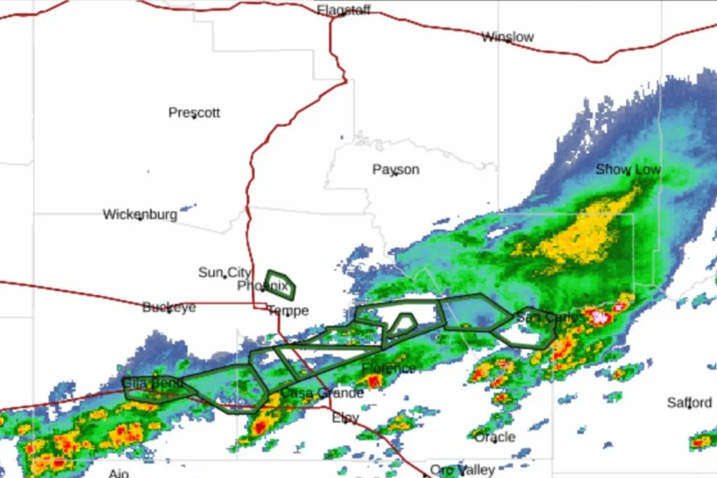
Animated weather radar indicated thunderstorms and torrential rain impacting areas near Phoenix and extending into northern and eastern Arizona. Rainfall totals were expected to reach 3 to 4 inches in central Arizona, with local amounts up to 6 inches possible -- a significant trigger for flash flooding.
Flood and weather watches were activated in neighboring states as well, including Utah, Colorado, Nevada, New Mexico, as well as parts of California.
The NWS Weather Prediction Center noted, "Greatest rainfall amounts are expected across south-central AZ, especially N [north] and E [east] of PHX," while lighter rain would spread through a wider area.
NWS Phoenix advised residents to avoid driving through flooded areas and to stay alert as rainfall increases, saying, "Be aware of your surroundings and do not drive on flooded roads."
"Most flood deaths occur in vehicles," the agency warned.
The National Weather Service said in an advisory Sunday: "At 1050 AM MST, the public reported thunderstorms producing heavy rain across the warned area. Between 1 and 1.5 inches of rain have fallen. Flash flooding is already occurring. HAZARD...Life threatening flash flooding. Thunderstorms producing flash flooding...Life threatening flash flooding of creeks and streams, urban areas, highways, streets and underpasses."
Arizona Department of Transportation wrote on X Sunday: "Westbound Loop 202 Santan is now closed at Cooper. Pumps are working, but the storm cell that just passed over the SE Valley dropped a bunch of rain here. Our hydrovac crews are responding help catch up and open lanes."
The immediate flash flood warning in Arizona is set to expire at 1:45 p.m. Mountain Standard Time, but flood watches and alerts will persist through Sunday as rain bands from Priscilla continue to impact the region.
Residents are advised to remain alert to rapidly changing weather conditions and to follow safety guidance from local emergency officials.