Firefighters are bracing for catastrophic conditions as a blistering heatwave grips much of Australia, bringing soaring temperatures and heightened fire risk through Friday.
The Bureau of Meteorology has issued heatwave warnings for New South Wales, Queensland, the Northern Territory, Western Australia, and South Australia, with temperatures forecast to climb well above seasonal averages.
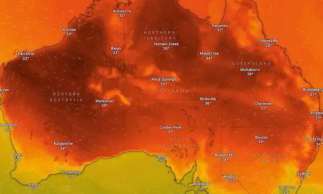
Sydney and Brisbane are expected to swelter through 35C-plus days on Wednesday and Thursday, with overnight temperatures of 19C.
South Australia is expected to endure 45-46C, while parts of southwest Queensland may hit a scorching 47C. Northwest NSW and the southern Northern Territory are also bracing for low-to-mid 40s.
Humid conditions are fuelling destructive thunderstorms, bringing the risk of large hail, heavy rain, and damaging winds in the coming days.
Authorities have warned of extreme fire danger, the second-highest rating, in 10 NSW districts today, including Greater Sydney.
The state's first catastrophic fire danger rating of the season has been declared for the Lower Central West Plains, meaning fires in these areas will be fast-moving and uncontrollable.
No region of NSW has had a catastrophic fire danger forecast since September 2023.
In a precautionary move, the NSW Department of Education has closed 25 public schools in the Riverina region ahead of the forecast dangerous conditions.
The affected schools include: Ariah Park Central School, Barellan Central School, Bedgerabong Public School, Binya Public School, Bogan Gate Public School, Boree Creek Public School, Caragabal Public School, Ganmain Public School, Greenethorpe Public School, Lake Wyangan Public School, Lowesdale Public School, Marrar Public School, Matong Public School, Naradhan Public School, Narrandera East Infants School, Narrandera High School, Pleasant Hills Public School, Tallimba Public School, Tharbogang Public School, The Rock Central School, Ungarie Central School, Wamoon Public School, Weethalle Public School, Whitton-Murrami Public School and Yerong Creek Public School.
Emergency services are urging residents to avoid outdoor work during peak heat, stay hydrated, and have bushfire survival plans ready.
Meteorologists said the prolonged heatwave is being driven by hot air from inland Australia moving towards the coast while humidity drops. They warn the hot spell, while not unusual for late spring, could approach record-breaking November temperatures.
Meanwhile, a separate weather system sweeping over southern and central NSW will whip up strong, dry westerlies today creating dangerous conditions for downed trees and fast-moving fires.
The warning comes as Queenslanders who faced an 'insurance catastrophe' hailstorm event on Monday are being warned to prepare for more bouts of poor weather.
Severe thunderstorms with large hailstones, damaging winds, and heavy rainfall again hit parts of Ipswich, Logan, Somerset, Southern Downs, Western Downs, South Burnett, and Toowoomba on Tuesday night.
Damage caused by Monday's storm alone saw more than 16,000 insurance claims lodged across 140 postcodes in what was called an 'insurance catastrophe'.
Energex said the ongoing storms in SE Qld cut power to an additional 11,000 customers.
'Despite this, our crews have done amazing things and restored power to thousands more customers overnight,' a spokesperson said.
'Currently, we have nearly 40,000 customers still without power - including a mix of those who've been without power for days and new outages from overnight storms.'