A major Forest Service overhaul comes as wildfire risk climbs. Experts warn it could impact response and research.
Another round of severe weather was threatening states in the central United States on April 17 with potential thunderstorms, destructive wind, hail and even tornadoes.
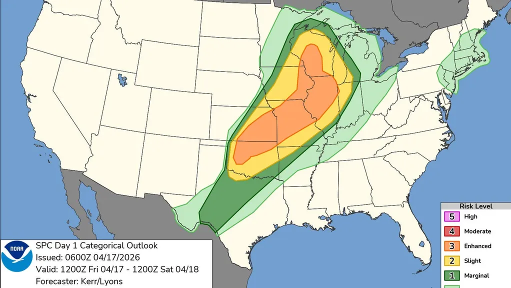
More than 22 million people in major cities including Chicago; Kansas City, Missouri; Tulsa, Oklahoma; Wichita, Kansas; and Madison, Wisconsin, were at an enhanced risk for severe storms on April 17. Forecasters said states in a stretch of the central U.S. from Texas up through the Midwest are expected to see unsettled weather, with the most severe risk of "strong to intense" tornadoes from eastern Iowa into Wisconsin and northwest Illinois, the Storm Prediction Center said.
Thunderstorms and heavy rain with rates of 1 to 2 inches per hour could also spell scattered flash flooding, especially in places that have already seen accumulating rainfall this week, the National Weather Service said.
The weather threat comes after back-to-back days of unsettled weather earlier in the week that saw reports of several tornadoes. At least eight tornadoes were confirmed in Michigan overnight from April 14 to April 15, reported the Detroit Free Press, part of the USA TODAY Network. A tornado in Juneau County, Wisconsin, on April 14 was the state's strongest since 2021, according to the Milwaukee Journal Sentinel, also part of the Network. A home there was leveled and the roof was torn off a church in Waukesha County.
"This stormy pattern has evolved into a multiday severe weather outbreak, with the most dangerous conditions expected Friday," said Adam Douty, AccuWeather senior meteorologist. "Friday's setup has all the ingredients for significant severe weather, including destructive hail, damaging winds and tornadoes."
Week of storms to escalate on April 17
The severe weather week will peak on April 17 before the threat shifts eastward, according to AccuWeather.
The risk will start off with large hail and the chance for a few tornadoes and will shift to primarily damaging winds with gusts 75 mph or greater through the evening, the Storm Prediction Center said.
In the upper Mississippi Valley and Midwest, a "window of opportunity" for supercell development is possible within an environment that could be conducive to "strong tornadoes." A stretch from south-central Kansas toward northwestern Missouri could see hail larger than 2 inches in diameter and a potential for a few tornadoes, according to the Storm Prediction Center.
"People in the path of these storms should stay alert and be ready to act. Make sure your phone is charged, alerts are on, and your storm shelter or safe place is ready and stocked with emergency supplies. Never drive on flooded roads, especially at night," AccuWeather senior meteorologist Dan Pydynowski said.
Stormy weather to shift east over the weekend
The severe weather threat will shift eastward, extending from Arkansas to southwestern New York and covering much of Ohio on April 18, AccuWeather reported.
Tornadoes, damaging winds and hail are all possible across that region.
The threat should diminish by April 19, but some thunderstorms and heavy rainfall in parts of the Gulf Coast and Atlantic Coast are still possible, the outlet reported.