Villagers have ridiculed a council's decision to register a public byway which runs through an impassably deep thicket before ending at a dangerous, crumbling cliff face.
The 650ft route in Sidestrand, Norfolk, was formally declared 'open to all traffic' - which includes cars, pedestrians, horse riders and cyclists - after a lengthy four-year process.
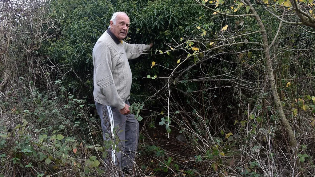
Residents living at the inland end of the public path were alerted to the decision in letters issued by the council. Signs were also installed to announce the public right of way.
But Sidestrand parish councillor Ivor Watkins said: 'It is as if they are inviting you to drive up to the cliff edge.
'If they had come and had a proper look, I'm sure they would have realised "What are we doing here?"'
Another local wrote to the council to object, saying: 'I cannot see any reason to adopt this as a byway, it goes nowhere except over a cliff.
'The danger to public transport is huge in my view to modify the route into a byway.'
A dog walker who gave his name as Simon, and who said he had been a visitor to the area for years, added: 'It is a road to nowhere.'
Cllr Watkins said he installed signs at the start of the route some years ago which stated: 'Only residents' cars beyond this point.'
He took action because holidaymakers kept driving down the short track past a row of houses thinking it led to the beach and then had to carefully manoevre their way back out again when they hit a dead end.
This, he suspects, led to the council coming under pressure to act from the Open Spaces Society (OSS), a group which campaigns to preserve public rights of way.
But Cllr Watkins warned the sand and clay cliffs have become increasingly unstable in recent years as erosion has accelerated.
'I moved here in 1991 and in that time we had one major collapse,' he said.
'But this [past] year we had three or four. It is getting worse.'
The registration of the byway was done under a modification order, the formal process under which routes are recorded on local authorities' definitive map of local rights of way.
The OSS confirmed it had provided the council with evidence about the route's status, including old maps that showed it had existed for centuries.
In its submission, it said: 'All the evidence produced for the route suggests that vehicular rights existed... these rights have not been extinguished.'
A spokeswoman added: 'Research by the Open Spaces Society revealed that this route has always been a public byway and that it was wrongly signed to restrict vehicular use.
'We were motivated to claim this route because on January 1, 2031, it will no longer be possible to apply to record historic highways on the definitive map.
'A year ago the government promised to repeal that deadline but has failed so far to introduce the necessary legislation.'
Ben Nutall, a public rights of way officer at the county council, said the byway was previously the old route of the A148 Coast Road, until it was moved inland due to erosion.
'It goes right up to the cliff edge. Furthermore, even though the last 50m or so of the route is largely inaccessible due to thick vegetation, the surface still has highway rights over it,' he added.
Cllr Watkins said it was a 'waste of public money' to have gone through the process.
But others backed the council and OSS, with one commenting online: 'It does seem a bit odd but correct in a perverse way.'
Another said: 'It's just about asserting ownership. They are correct in doing this.'
England and Wales have over 140,000 miles of footpaths, bridleways and byways making up the public rights of way network.
The routes historically provided ease of movement for commerce, farming, socialising and pilgrimage and were accepted under common law.
More recently, legislation have been introduced to formally protect the routes.
The Ramblers group, which also campaigns to protect public routes and has identified over 49,000 miles of paths that are not recorded on definitive maps, says on its website: 'When public paths aren't recorded, the local authority is unlikely to resolve problems like locked gates or intimidating signs. Unrecorded paths are also vulnerable to development. 'Therefore, it is vitally important that unrecorded paths are claimed by the public and added to the Definitive Map so that they get the protection to which they are legally entitled.'