The polar vortex is a large area of circulating cold air above the North Pole. Strong winds keep it contained, but when it weakens, it can wobble and stretch.
Dangerously cold temperatures combined with wind gusts up to 60 mph are expected to cause life-threatening conditions across parts of the Midwest, Mid-Atlantic and Northeast to close out the week, forecasters said.
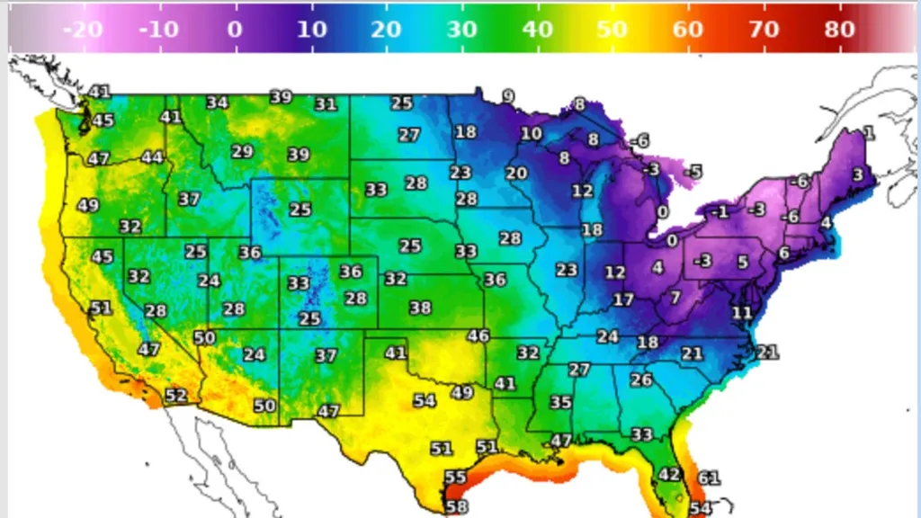
A blast of Arctic air is poised to enter the United States from Canada beginning Feb. 6 and stretching through the weekend because of a displaced polar vortex. The pattern could also bring some snow ahead of the frigid temperatures, AccuWeather reported. Temperatures in major cities including Detroit, New York City and Boston are expected to plummet into single digits, with wind making it feel much colder.
"The Arctic air combined with gusty winds could make it feel colder than any other point so far this winter," AccuWeather Chief Meteorologist Jonathan Porter said.
More than 43 million Americans were under extreme cold warnings the morning of Feb. 6. Millions more were under winter weather advisories and high wind advisories.
The coldest temperatures will be felt in the interior Northeast and New England, according to the National Weather Service. Wind chills will get as low as the minus 30s.
"These wind chills will pose a life-threatening risk of hypothermia and frostbite to exposed skin," the weather service said.
How cold will it get?
The cold air sweeping into the country starting on Feb. 6 will escalate on Feb. 7, when the weather service said high temperatures will remain as low as the single digits, teens and low 20s. In the interior parts of New England and the Northeast, wind chills could reach the minus 30s, while coastal areas will reach below 0 into the minus teens on Feb. 7 and Feb. 8.
Here's how cold the wind chills could get in major cities:
- Boston: As low as minus 30 overnight Feb. 7
- New York City: Minus 15 to minus 25 the night of Feb. 7
- Detroit: Minus 10 to minus 20 overnight Feb. 6 into Feb. 7
- Washington, D.C./Baltimore: Minus 5 to minus 10 on Feb. 7
The polar vortex is responsible for the blast of cold air
The polar vortex is a huge area of cold air high up in the atmosphere that usually spins over the North Pole. Its position impacts where in the United States cold air can invade. When the polar vortex weakens or is disrupted, the cold air can surge out.
The polar vortex has been weaker this week, allowing the Arctic air to flood into the United States and other places around the globe, AccuWeather reported.
Snowfall expectations
The weather service said light to moderate snow showers will spread from the Great Lakes region into the Northeast and Appalachians starting on Feb. 6. Most accumulations will be in the range of 1 to 3 inches. The snow will spread into coastal New England on Feb. 7, where 4 to 5 inches could fall, the weather service said.
How to stay safe in the dangerous cold
The National Oceanic and Atmospheric Administration said the extreme cold combined with strong wind gusts could cause life-threatening conditions this weekend, and gave the following survival tips:
- Have a cold-weather survival kit if traveling.
- Limit time outdoors and cover exposed skin if outside.
- Ensure pets and livestock have adequate protection from the cold.
- Take steps to prevent frozen pipes, and avoid walking on frozen bodies of water where ice thickness is uncertain.